- AppSheet
- AppSheet Forum
- AppSheet Q&A
- Re: Viewing LatLong capture as text in read only/t...
- Subscribe to RSS Feed
- Mark Topic as New
- Mark Topic as Read
- Float this Topic for Current User
- Bookmark
- Subscribe
- Mute
- Printer Friendly Page
- Mark as New
- Bookmark
- Subscribe
- Mute
- Subscribe to RSS Feed
- Permalink
- Report Inappropriate Content
- Mark as New
- Bookmark
- Subscribe
- Mute
- Subscribe to RSS Feed
- Permalink
- Report Inappropriate Content
Hi
I have a couple of apps that users manually capture location using the app, these locations are then viewed by other users to get to that location.
The difficulty is that the captured locations show as a tiny map on the app and can't be opened or zoomed in on.
the same issue occurs where these locations are put in a PDF template.
I've tried to change the format rules for these columns however it seems to make no difference to how the information is displayed.
Is it possible to do either of the following:
- Display the LatLong as text in the app(ie the coordinates)
- Hyperlink the Map to a map page(GoogleMaps?) from the app?
I've tried to follow the Appsheets template instructions but it still defaults to a Google Maps fixed image.
Thanks
- Labels:
-
App Management
-
Expressions
- Mark as New
- Bookmark
- Subscribe
- Mute
- Subscribe to RSS Feed
- Permalink
- Report Inappropriate Content
- Mark as New
- Bookmark
- Subscribe
- Mute
- Subscribe to RSS Feed
- Permalink
- Report Inappropriate Content
@Chalky23456 wrote:
The difficulty is that the captured locations show as a tiny map on the app and can't be opened or zoomed in on.
the same issue occurs where these locations are put in a PDF template.
Not sure , why you say so. Could you elaborate with more details? Were you able to try the map views to display different locations?
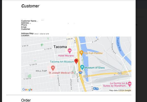
The PDF as well as map view show sufficient details around a pin.
In a record's detail view, yes the image is small, but if the user clicks on it , it navigates to a map view with sufficient details.
The image below is a PDF report with latlong location displayed in a map.
Please take a look at the following sample app mentioned at the help article Get started by using the sample apps - AppSheet Help to get ideas on using Latlong columns in an app.
Interactive Map Dashboard - AppSheet
- Mark as New
- Bookmark
- Subscribe
- Mute
- Subscribe to RSS Feed
- Permalink
- Report Inappropriate Content
- Mark as New
- Bookmark
- Subscribe
- Mute
- Subscribe to RSS Feed
- Permalink
- Report Inappropriate Content
Thank you. I've struggled a bit as I did not set the original build up and have very little access to the person who did.
The build shows the map as a link in one version of the app that can be clicked on, it only opens up to a fixed image of the map though which is no use for our purposes. there is also a read only version of the form that shows the location as a fixed picture that can't be interacted with. I have found a way round this within the app now by hyperlink but still need to display the LATLONG as a text(or decimal) within the PDF template though. At the moment it defaults to a map as below which can be clicked on but only opens as a fixed picture of the location, I need it to show as it does highlighted in orange so that it can be used in systems other than Google.
-
!
1 -
Account
1,686 -
App Management
3,141 -
AppSheet
1 -
Automation
10,381 -
Bug
1,000 -
Data
9,729 -
Errors
5,775 -
Expressions
11,852 -
General Miscellaneous
1 -
Google Cloud Deploy
1 -
image and text
1 -
Integrations
1,627 -
Intelligence
582 -
Introductions
86 -
Other
2,936 -
Photos
1 -
Resources
544 -
Security
837 -
Templates
1,317 -
Users
1,565 -
UX
9,140
- « Previous
- Next »
| User | Count |
|---|---|
| 37 | |
| 31 | |
| 28 | |
| 22 | |
| 18 |

 Twitter
